Meteorologists Tracking Potentially Big Weekend Snow Storm
PITTSBURGH (KDKA) - If you've been on social media over the past couple of days, you have probably run into a post about the potential big snow storm and eventual Nor'easter heading for the East Coast, including Pennsylvania.
At this point, KDKA-TV Meteorologist Ron Smiley is monitoring the situation, but parts of our area will eventually be impacted by the storm.
The forecast is calling for an area of low pressure currently located over the Dakotas into Washington State to develop and wrap around the cold air that is in place here in Pennsylvania.
This track will take the system south over Northern Louisiana where it will pick up moisture. At this point, it will mainly be rain that we will be seeing as the system picks up speed and heads to the northeast.
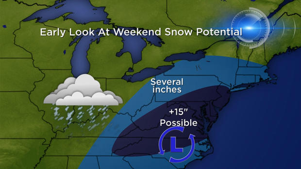
With cold air located to the north, we will quickly see rain turning over to snow on the system's north and west sides. As the low tracks over North Carolina and southern Virginia, places to the north will likely see big snow totals with mainly rain to the south.
The system will then turn into a Nor'easter as it hugs the East Coast. Winds on Sunday and Monday will cause more issues as blowing snow becomes a problem for places in Eastern Pennsylvania and along the East Coast.
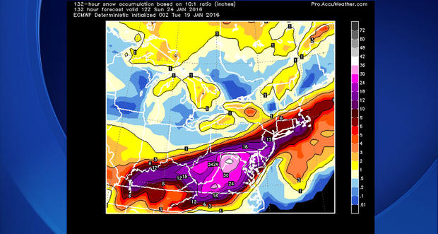
Smiley says, as impressive as the numbers are that are coming in from data on potential snow totals, we are still four days out from the first flake falling and this system is literally a country away.
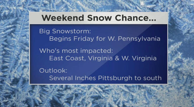
Small changes to the track will occur and will impact millions of people. With that being said, at this point, it appears parts of West Virginia and Virginia are in the bullseye for the storm with perhaps as much as two feet of snow getting dumped in some of the higher elevated areas.
These two states could be buried in nearly a foot of snow on average on the ground by Saturday afternoon as the system continues to push off to the northeast.
The dividing line, between those who get a large amount of snow and those that don't see as much, looks to be the Laurel Highlands. Places along and south of that area could see more than a half-foot of snow with places north likely seeing less than a half-foot of snow.
Join The Conversation On The KDKA Facebook Page
Stay Up To Date, Follow KDKA On Twitter