Chief Meteorologist Jeff Verszyla's 2016-17 Winter Weather Forecast
PITTSBURGH (KDKA) – Last winter could be best described as being weirdly warm.
People were jogging shirtless and even spring flowers were blooming. It was definitely the perfect winter for people who love summer.
Eventually, we did see some snow, but it was nowhere near what we're used to.
Furthermore, it stayed pretty warm all the way until spring.
Now, with another winter right around the corner, Chief Meteorologist Jeff Verszyla has completed his annual winter weather forecast.
First, let's recap last winter.
Temperatures were above average for four out of the five months. That included the second-warmest December on record and mid-60s temperatures on Christmas Eve.
Snowfall was under 30 inches, which was our lowest total in 14 years.
To help with this year's forecast, Verszyla went to AccuWeather in State College to meet with the forecasters and discuss what we're in for this year.
So, let's get into the specifics.
El Nino
Last winter we talked a lot about how our mainly mild weather was driven by a record-setting El Nino event.
El Nino is a weather phenomenon that happens every few years and basically flip-flops the water flow over the equatorial Pacific Ocean, which causes the water to warm.
In other parts of the world, strong El Ninos can cause problems.
In a nutshell, that usually means milder weather for the northeastern United States.
Unfortunately, El Nino's influence has faded over spring and summer. This winter, a minor La Nina could have a weak influence.
La Nina is the opposite of El Nino and this one is projected to be rather weak.
What it all boils down to is the deck is stacked altogether differently this winter.
"We're looking at weak La Nina conditions in the first part of the season, then gradually goes into a neutral state, which means other signals will come into play as we get into the middle part of winter," Paul Pastelok, AccuWeather's lead long range forecaster, said.
With no clear signal to guide the winter pattern, the best course of forecasting is to lean toward some other large scale influences with a similar setup from previous seasons.
"What we've seen in those years is that there has been some type of charge of cold at some point in December," Pastelok said. "The other thing is, that in those years, January was rough."
"Snow-wise, we've seen in neutral events, we get frequent events during the course of the year, then one or two big ones."
So, here's what Verszyla expects for our winter.
Temperature Outlook
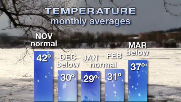
The season should start pretty normal in November with temperatures for the month averaging 42 degrees.
Then, December should provide a more pronounced introduction to winter. Fast moving fronts will bring brief, but with more noticeable cold shots. This will push temperatures below normal to an average of 30 degrees.
The invasions of colder air will increase in January and February with the occasional dip in the Polar Vortex. However, average temperatures will likely be near normal - right around 30 degrees both months.
Finally, an early spring warmup doesn't appear to be in the cards. A slow transition in March will keep temperatures below normal, with an average of 37 degrees for the month.
In the end, January will be the coldest month of the winter. It'll likely be a slow climb out of winter in March with a lingering chill toward the start of spring.
Overall, the season's temperatures will be very close to normal.
Monthly Snowfall
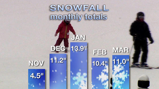
The season will start with fast and frequent systems moving across the northern U.S. in November and December.
While we'll only have a little bit of snow at a time, we'll see snow more days than not during those months. Snow will quickly add up, which will lead to above average totals through the end of 2016.
If you're hoping for a White Christmas, there's a decent chance you'll get one.
In January, the overall pattern should slow down, which will lead to the possibility for bigger systems. That means there's potential for higher accumulation with each storm.
Verszyla is forecasting nearly 14 inches of snow for January.
February should bring a lull in the storm track, but Verszyla still thinks snowfall for the month will be near the normal 10 inches.
In March, the extension of the winter chill will keep the flakes flying with an above normal accumulation of 11 inches.
Over the next five months, Verszyla expects a total of 51 inches of snow, which is 11 inches above average and 21 inches more than last winter.
Bottom Line
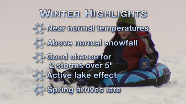
Temperatures will be near normal, though it'll probably feel a little colder to us because of how warm last winter was.
We're going to have more snow than normal, with a good chance for a few bigger storms in January.
For the snow belt areas, it should be a more active lake effect season.
Spring will take its time showing Old Man Winter the door in March.
So, how will this impact you?
- Heating costs for your home will be higher.
- Plan on more school delays and closings for your kids.
- Make sure you have a solid snow shovel.
- If you work in the snow removal businesses, expect more work, but on the flip side, that probably means more pay.
- If you ski, you'll likely get more bang for your buck with a season pass.
Join The Conversation On The KDKA Facebook Page
Stay Up To Date, Follow KDKA On Twitter