Ron's Weather Blog: Some Snow Could Arrive This Weekend
Every week over the winter weather months I am going to be writing a blog about potential snowfall specifically focused on the upcoming week. On top of that, I would like to look ahead (sometimes way ahead) at what the weather may be like due to what's happening right now in our atmosphere.
PITTSBURGH (KDKA) - Here comes the snow. OK, it's likely not going to be a lot, but still the season's best chance for snow should occur over the course of the weekend. Obviously, a lot can happen and the forecast can change, but we are still going to talk about what you may be in store for.
A brief warm up for Thursday and Friday before cold air and seasons first light snow chance for Pittsburgh arrives Sunday to Monday. #kdkawx pic.twitter.com/MPyBC10wTM
— Ron Smiley (@RonSmileyWx) November 14, 2016
Disclaimer:
I'm probably going to begin to post this each and every week. I blog once a week on Monday and I talk about the chance for snow for that week and beyond. Change is part of the definition of weather and we know things certainly change. This blog is designed to let you know what may occur and track patterns that you need to know about.
One of the key things you will notice in my blog is that I start with tracking cold air. My reasoning is simple. You can't have snow without cold air, which is something that we can do a pretty good job of tracking. What we don't do a good job of tracking, more than three days out, is moisture and trigger mechanisms like cold fronts and mid-level lows.
With that being said let's get into this week's snow blog.
Forecast through Saturday:
Not much to see really so we will make it short. The coldest days in the period will be on Monday and Tuesday with a nice warm-up from Wednesday through at least Friday. Saturday is looking all wet with highs near 60 degrees with rain showers possible during the day.
There is some disagreement on if rain will arrive on Saturday or on Friday. I am pushing back the arrival of rain and the cold air push until Sunday. I'm watching closely at this point. Some data points to the cold air and rain arriving on Saturday. Either way, we shouldn't see any snow through the end of the week. Things will be changing quickly though as we head into next week.
Sunday & Monday:
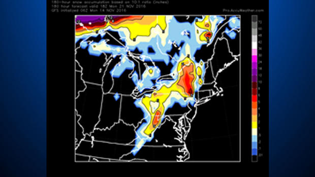
Our best chance for snow this early in the season arrives on Sunday and Monday. It's still pretty far out so a lot can and will likely change, but model data is showing as much as 3 inches of snow falling in the Laurel Highlands with a dusting to low accumulations possible for most of western Pennsylvania.
Temperatures during the day on Sunday aren't really cold enough for anything sticking around for too long and roads will be wet, but we don't foresee any big impacts on area drivers.
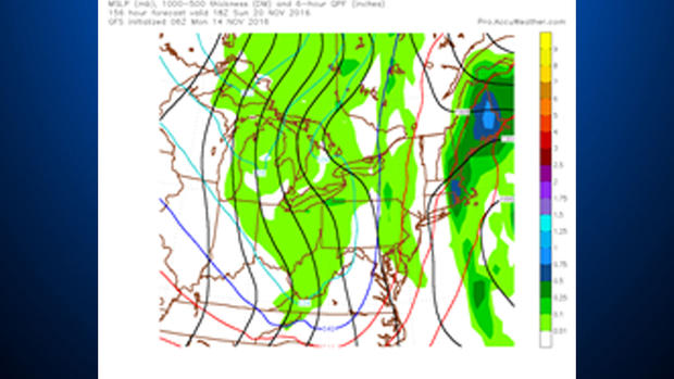
Conditions for snow won't stick around too long as we see the trough quickly deepen right on top of us before it slides to the northeast as it weakens - 1000mb to 500mb thickness values will go from 565 (That's warm for this time of year) down to 527 (snow is possible with anything generally below 540) decimeters by Monday morning.
We will return to about 550 by Wednesday, meaning more seasonal weather should return for the middle of next week.
Extended forecast:
Temperatures are expected to be too warm for any snow on Thanksgiving day and Black Friday. The only concern at this point is exactly how long the colder weather will stick around. At this point, it looks like we remain cold with at least a chance for snow through Tuesday.
Join The Conversation On The KDKA Facebook Page
Stay Up To Date, Follow KDKA On Twitter