Ron's Weather Blog: Snow Chance Looms On Horizon
Every week over the winter weather months I am going to be writing a blog about potential snowfall specifically focused on the upcoming week. On top of that, I would like to look ahead (sometimes way ahead) at what the weather may be like due to what's happening right now in our atmosphere.
PITTSBURGH (KDKA) - Over the past couple of years, we've seen at least a trace amount of snow in October. However, we didn't record any snow this year at the Pittsburgh airport for the month. Last time that happened was in 2010.
We did have a chance for some winter precipitation though. A mid-level low pushed through our area on Wednesday and Thursday, bringing with it a snow chance for places off to the northeast. For the month, we also had snow recorded at Hidden Valley and Seven Springs a little over a week ago. While most saw only rain it was just cold enough to get a couple of sleet reports off higher elevations. The mid-week system also brought accumulating snow into parts of New York.
This Week
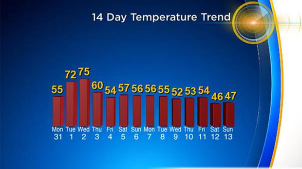
The chance for snow this week looks nonexistent with a nice warm-up set for Tuesday and Wednesday. We do cool down in time for the weekend with moisture moving out of our area just when temps dip enough to potentially support some type of winter precipitation on Friday morning. Even if the moisture lags, a quick glance at temperatures shows it only marginally conducive to anything other than rain. We are going to have to wait another week at least before we have a decent chance at seeing snow.
Two Weeks Out
The good news is that there is a decent chance for our first accumulating snow at the end of next week. I think this is a good time to talk about what I consider a good chance for snow.
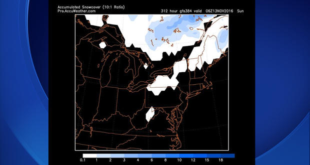
Only one gridded model that I have access to goes out past 10 days and that is the GFS. It continues to try and show some snow developing between the Nov. 10-15. Even if it wasn't though, the chance for snow would be there due to a couple of factors.
First, data from the GFS and other long range models (non-gridded) show a chunk of cold air rolling in from the Northeast during this time period. We also continue to see an active polar jet in our area being possible with data coming in.
All this together means that while not a guarantee; we will at least have a solid chance to see some light snow during this time period.
Cold air impacts area in the middle of the month.... today? Highs in the 70s! Enjoy... pic.twitter.com/MFei9n27Nk
— Ron Smiley (@RonSmileyWx) November 1, 2016
Moving Forward
It's time to get prepared. Winter weather is literally right around the corner. The cold air that we are tracking moving in from the Northeast will easily be some of the coldest air we have seen this season with highs potentially only in the mid-30s for a couple of days.
This is your friendly reminder that while we will give you plenty of heads up on when the snow is coming, there's going to be a rush on shovels, salt, and anything else you can throw at cold weather within the next couple of weeks. You may be able to find some of these items on sale currently, but in two weeks it may be hard just to find.
We continue to monitor some very cold air that is sitting over Siberia. This area is mainly flat and large (about half the size of the U.S.). The large chunk of land (about 9 percent of the Earth's dry landmass!) can help shape our winters by cooling large air masses before they are pushed with westerlies to the southeast. We have one such piece of very cold air that continues to sit on top of snow covered Siberia.
The cold air will continue to develop over the next two weeks. It will likely break off and move our way in December and will likely mean a chance from seasonal to slightly warmer weather to a cold month or two of weather. At this point it's coming…. It's only a matter of when it is set to arrive…
One of the things that is keeping the cold air away at this moment is a blocking high sitting over Alberta, Canada. It's also the reason that our mid-November chilly air is expected to slide in on the backs of northeast winds.
In Summary
- Seasonal snow so far at the Pittsburgh airport: 0.0"
- Last year's snow total through this time? T
- Forecast for the next 3 days: No snow
- Forecast for the next 7 days: No snow
- Forecast for the next two weeks: One model average of 0.26" precipitation (10:1 ratio 2.6" of snow)
Join The Conversation On The KDKA Facebook Page
Stay Up To Date, Follow KDKA On Twitter