1-3 Inches Of Snow Expected As Latest Round Of Winter Weather Arrives
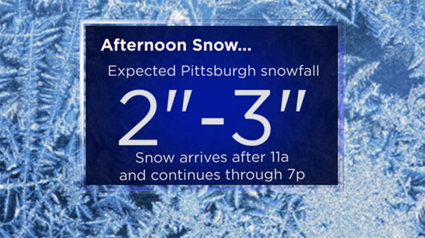
PITTSBURGH (KDKA) - A quick blast of 1-3 inches of snow is expected to fall through the afternoon hours today with travel during one of the busiest times of the day being impacted.
A Winter Weather Advisory is in effect until 10 p.m. for the following counties:
Allegheny, Armstrong, Beaver, Butler, Clarion, Indiana, Washington and Westmoreland.
Road crews will likely be out in full force from 3 p.m. through 7 p.m. clearing snow.
Snow will roll in from the west with any accumulating snow arriving after 11 a.m. The heaviest snowfall is expected along and just north of Interstate 80.
Lake effect snowfall could bring up to 8 inches of snow in isolated areas in northern Mercer and Venango counties. Snowfall of around an inch is expected for places south of I-70 with the possibility of snow and freezing rain in a narrow band along the West Virginia-Pennsylvania state line.
The heaviest snowfall should begin to wrap up after 6 p.m. with accumulating snow ending around 7 p.m. for the area.
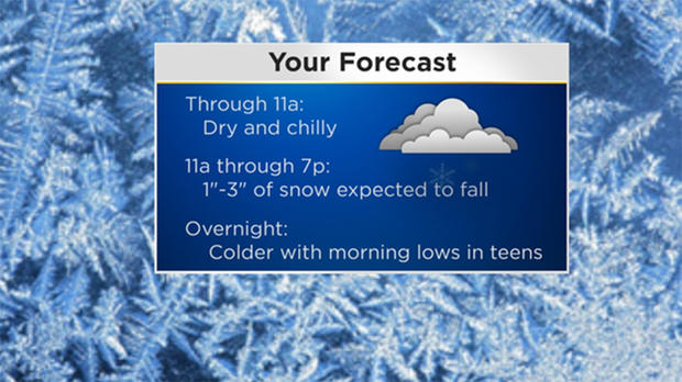
The coldest air of the season so far rolls in for the rest of the week. Highs on Wednesday should be in the 20s with highs in just the teens on Thursday.
We could fall to single digits on Friday morning.
Temperatures warm up on Saturday, but snow, rain and potential ice during the early morning hours may mean a nasty commute for anyone who has to leave the house early in the day.
Join The Conversation On The KDKA Facebook Page
Stay Up To Date, Follow KDKA On Twitter