Chief Meteorologist Jeff Verszyla's 2017-18 Winter Weather Forecast
Follow KDKA-TV: Facebook | Twitter
PITTSBURGH (KDKA) - It was a summer of wild weather in parts of the country.
Now, with winter on the way, are we in for a wild or mild one here in western Pennsylvania?
Last Winter, you'll remember we experienced above average temperatures.
In fact, from November to March there was at least one day every month that even had a record high temperature.
We also saw a lot less snow than usual. The snow total for the season was 32 inches, which was 10 inches below average.
Last year's mostly mild winter was driven by big influences, mainly ocean water temperatures and the phenomena known as La Nina and El Nino.
Paul Pastelok is the Lead Long Range Forecaster at AccuWeather in State College.
"La Nina and El Nino over the past several years have gotten a lot trickier. It seems like it doesn't always work the way it's supposed to work, especially last year," he said.
Last winter was a weak La Nina season, and the National Oceanic and Atmospheric Administration has predicted another weak La Nina this winter.
However, it'll impact western Pennsylvania a little differently this year.
"This year, we think La Nina may actually be a little more behaved and do what it's supposed to do," Pastelok said.
That influence alone would make for a colder and snowier winter than last year.
Unfortunately, it's not quite that simple.
"We spend months ahead looking at things, how things change and then comparing that to other years," Pastelok said.
So, how do hours and hours of research into a dozen different global weather signals translate to our local pattern this year?
"I expect more of those clipper style systems to come down. And usually those kinds of systems bring more frequent, not major snow events, but more frequent snow events to places in the Ohio Valley, Great Lakes and western Pennsylvania," Pastelok said.
So, given that projected setup and comparing it to similar patterns from previous years, here is what KDKA-TV Chief Meteorologist Jeff Verszyla expects for our winter.
First, let's discuss temperatures.
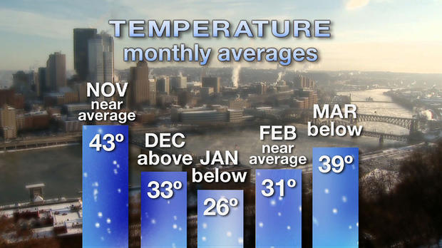
November should bring near average temperatures, around 43 degrees, with a few quick shots of cooler air.
December should be warmer than average, around 33 degrees, with fast-moving fronts providing brief, but more noticeable cold shots.
January will likely be the coldest month of the season with below average temperatures, around 26 degrees.
February looks to bring occasional thaws, keeping the temperatures near average, around 31 degrees.
March is expected to bring below average temperatures, around 39 degrees.
Overall, the winter will end with temperatures very close to average, but colder than last year.
Now, let's discuss snow.
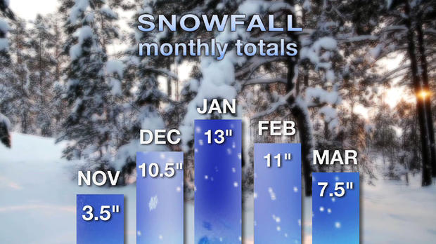
The season will start out slow in November with only 3.5 inches expected over the month.
However, we'll see a lot more snow in December than we did last year, with 10.5 inches expected.
By January, the pattern should become colder and more active, which will lead to the potential for higher accumulation, around 13 inches.
February should bring a relative lull in the storm track, but a couple healthier systems will bring snowfall for the month to 11 inches, which is near average for the month.
And the snow will continue through the first part of March, bringing us a near normal accumulation of 7.5 inches.
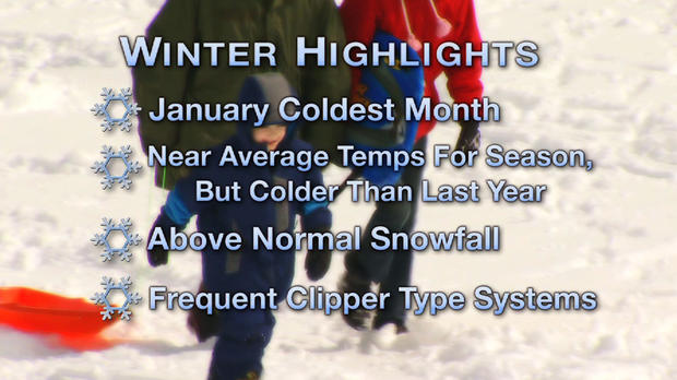
Overall, Verszyla predicts we'll see 45.5 inches of snow over the course of the winter, which is 13.5 inches more than last year and also above the average yearly snowfall of 40 inches.
Bottom line? We're in for a colder and snowier winter than last year, but more in line with what we know as a normal winter in western Pennsylvania.