Complex System To Bring Chance Of Rain, Snow & Freezing Rain To Western Pa.
Follow KDKA-TV: Facebook | Twitter
By: KDKA-TV Meteorologist Ron Smiley
PITTSBURGH (KDKA) - A complex weather system will impact western Pennsylvania on Wednesday, which will bring a chance for snow, rain and freezing rain at times.
Late Tuesday night, the National Weather Service issued a Winter Storm Warning through 6 p.m. for Allegheny, Armstrong and Jefferson counties.
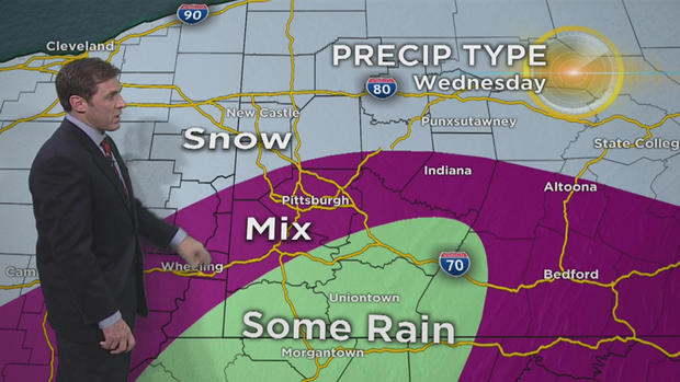
"Here's the hour-by-hour breakdown tonight and through the day [Wednesday]," said KDKA Chief Meteorologist Jeff Verszyla. "This is 2 a.m., I-70 on south, moisture arrives, quickly expands north, and by 7 a.m. - Lawrence, Butler, Beaver counties all seeing snow. You get into Allegheny County, it gets a little bit more dicey with some mixed precipitation; and the further south you go, the more likely you are to encounter some plain rain south of I-70 [Wednesday] morning, which will start to shift east then by late morning and early afternoon. Thankfully, it's a fast-moving system, so by 3, 4 o'clock the moisture peels away altogether.
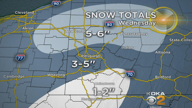
Verszyla says snow accumulations depend on where you are.
"You mix in liquid, that cuts down snowfall - 1-2 inches [south], in and around Pittsburgh 3-5, and where it stays all snow all the time to the north, you're looking at 5-6 inches of accumulation," he said.
WEATHER LINKS:
Delays & Closings | Current Conditions | Local Radar | Traffic Conditions | Weather App | Photos
KDKA Meteorologist Ron Smiley says the forecast will be fluid all the way through the day with rain falling in some areas and all snow being reported just miles away. Between the rain and snow will also be a chance for freezing rain and freezing drizzle. The numbers tell a mixed story when it comes to what to expect.
So, generally when I am forecasting, and I see the rain-snow line (540mb 1000-500 thickness) around and big precipitation totals like what I am seeing in data this morning, I generally lean towards rain. Model data oftentimes underperforms when it comes to the warm temperature push at the surface. The picture in my head is similar to what the RPM model shows with a snowy start to Wednesday (2 a.m. to 7 a.m.), then warmer weather and rain and then back to cold weather with another burst of snow as the cold front slides through. This is certainly one solution.
The other solution is the one painted pretty clearly by model data numbers that shows temperatures at all levels of the atmosphere marginally conducive for snow. This would mean a relatively wet snow for most places with temperatures hovering near 32 degrees.
Also, some big snow totals would then be possible if it is all snow. We are talking 6 inches or more for Pittsburgh with isolated snow reports of 8-10 inches.
So, the options are snow and rain or lots of snow.
At this point, I am going to adjust my forecast for slightly more in the way of snow with freezing rain still expected. That puts Pittsburgh still in the 2 to 4-inch range with higher totals in Butler, Lawrence and Beaver counties.
High snow totals will extend along Interstate 80 wrapping around northern Indiana County and then extending south through the Laurel Highlands. Totals may continue to go up this evening as confidence grows for more rain or even possibility of it all being snow.
Don't forget, temperatures are now expected for most of western Pennsylvania to be right around 32 degrees so slick spots will be likely on area roads.