Chief Meteorologist Jeff Verszyla's 2018-19 Winter Weather Forecast
Follow KDKA-TV: Facebook | Twitter
PITTSBURGH (KDKA) -- Like it or not, winter is coming.
Last winter was particularly cold and snowy. We had below average temperatures and above average snowfall totals in December, January and March.
By the time spring arrived, we'd seen 52.5 inches of snow, which is a foot above average.
So what can we expect this winter?
Well, we have to go back to summer to find out. That is when global patterns and large scale influences start to tip their hand.
Among the most analyzed are the water temperatures in various parts of the Atlantic and Pacific Oceans.
Of these, the most publicized are the phenomena known as El Nino and La Nina.
"The main influence that stuck out to us first is the transformation to El Nino. When was that going to take place? How strong was it going to be? And how much influence it would have on North American pattern?", says AccuWeather Long Range Meteorologist Paul Pastelok.
The National Oceanic and Atmospheric Administration agrees. Their latest outlook projects a 70 percent chance of an El Nino influence this winter.
Right now the signal is weak, but the long range experts at AccuWeather expect the intensity to briefly increase into the moderate range by the heart of winter.
"What that means is we're going to see a pretty active southern jet. Last year, we saw a pretty active northern jet, a lot of quick systems. The results of El Nino can be powerful systems, more moisture associated with them, but less frequency. The problem is that early in the season, the polar vortex that we always look for shifts in, looks like it's going to stay centered and that promotes more westerly flow across the country and that's not a really cold flow," says Pastelok.
However, a late season shift in the polar low could mean some a big pattern change for the second half of winter.
Given that expected set up, and with comparisons to similar patterns from years past, here is what's expected for our winter.
TEMPERATURES:
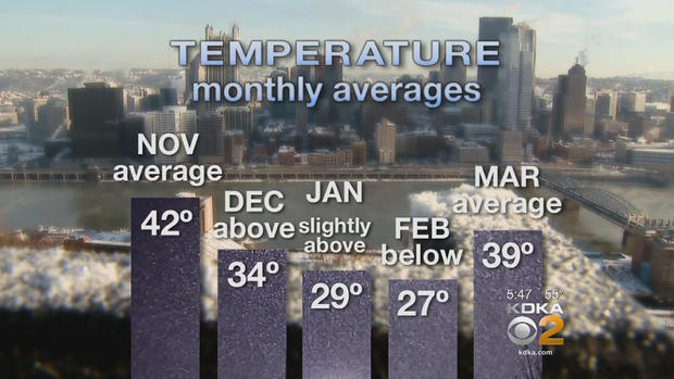
The season should start somewhat mild in November with a couple of quick shots of cooler air, but near the average of 42 degrees for the month.
December will feature a back and forth theme with transient cold air masses.
Pacific air will mix with fast-moving Canadian fronts to provide brief cold shots.
Overall, December temperatures will be above average at 34 degrees.
January will start milder than normal, but an invasion of Arctic air becomes more prominent by mid-month and beyond. Still, January will be slightly above average at 29 degrees.
February will feature the coldest air of the season, which will be locked in for longer periods and drop temperatures below average to 27 degrees.
March will come roaring in with early month chill. Then, the pattern will flip flop to a more spring-like feel the second part of the month, with near average temperatures of 39 degrees.
SNOW:
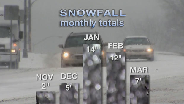
The season will start a little slow in November, with less than two inches of snow.
The meager snowfall amounts will continue into December as a fast-moving, zonal flow will promote warmer air and snow amounts of less than five inches through the end of the year.
In January, the pattern will gradually become more amplified, with a more active storm track, especially late in the month. This will lead to 14 inches of snow, the greatest accumulation potential of the entire winter.
A slight shift in storm track further south in February should bring a relative lull in snowfall frequency, but one or two healthier systems should bring the snowfall total for the month to 12 inches, which is slightly above average.
In March, the extension of the winter chill early in the month will keep the flakes flying the first couple of weeks. However, we'll see less than seven inches of snow throughout the month, just below normal accumulation.
All told, the total amount of snowfall over the winter is expected to be 39.5 inches. That is about average for winter in Pittsburgh and 13 inches less than last winter.