Cold Temperatures To Linger, Chance For Snow This Weekend
Follow KDKA-TV: Facebook | Twitter
PITTSBURGH (KDKA) -- Cold weather has arrived and will be in place for the rest of the month and likely beyond.
While we may still see a brief round of rain here or there, it looks like nearly all, if not all, precipitation for the rest of the month will be in the form of snow.
We are also watching the weekend for what could be the best chance for snow so far this season.
WEATHER LINKS:
Current Conditions | School Delays & Closings | Local Radar | Weather App | Photos
Here's your forecast for the next couple of days:
Rest of the day: Temperatures have fallen into the 20s and will be there for the remainder of the day. KDKA's Ron Smiley have today's low and tomorrow's high being hit at or right before midnight at 26 degrees. It is still very windy outside with gusts over 30 mph. Snow showers will remain spotty with isolated showers producing as much as a half inch of snow per hour. This could potentially cause issues for drivers with rapidly changing conditions.
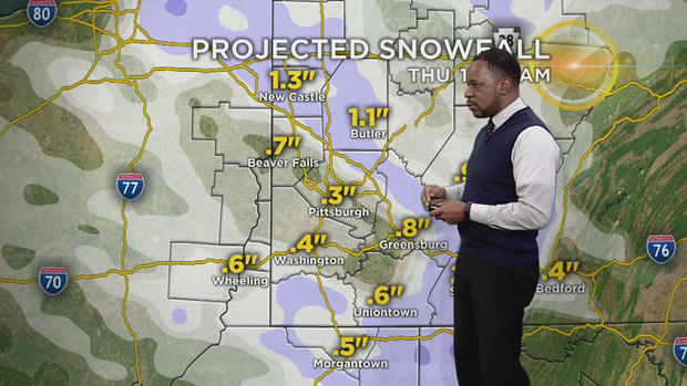
Thursday: More of the same. Temperatures continue to slowly fall. Snow showers expected especially during the morning. Midnight temps will be in the mid-20s. Temperatures will be in the mid to low 20s as we are heading into the afternoon.
Friday: Dry. High temperatures near 32 degrees.
Saturday to Sunday: Highs in the mid-30s with accumulating snow expected. A little too far out to talk snow numbers, but it looks like parts of the area could see criteria met for the issuance of a winter weather advisory due to some impact on travel.