Pittsburgh Weather: Winter Storm Watch Issued, Up To 12 Inches Of Snow Possible In Areas
Follow KDKA-TV: Facebook | Twitter
PITTSBURGH (KDKA) -- The National Weather Service has issued a winter storm watch for all of western Pennsylvania with up to 12 inches of snow possible in some areas.
According to the National Weather Service, heavy mixed precipitation is possible with total snow accumulations of 3 to 12 inches in some areas. Ice accumulations of up to one tenth of an inch are also possible.

The storm watch is in effect from Saturday morning through Sunday afternoon.
The National Weather Service says a winter storm watch means there is potential for significant snow, sleet or ice accumulations that may impact travel.
Amtrak has canceled Trains 42 and 43 on its Pennsylvanian line, which were scheduled to travel between New York and Pittsburgh with stops in Philadelphia and Harrisburg.
They also canceled Trains 662, 664, 672, 661, 667 and 671 on its Keystone line, which traveled between New York and Harrisburg.
Additionally, a number of airlines with flights in and out of Pittsburgh International Airport have waived change fees for the weekend.
All eyes are on the weekend with a chance for big snow totals as a major winter weather system is set to pass by Pennsylvania.
This system has yet to come together, and the system that it is expected to come from hasn't cleared the Rockies yet, so a lot can still happen. That means there's a good chance this snow map will change with what to expect. That being said it represents KDKA's Ron Smiley's latest thinking of what to expect in hopes that it will help you in preparing for the weekend.
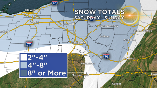
The highlight of the snow map is the eight inches or more part.
At this time, he's keeping the line for more than eight inches of snow north of I-80, but there is growing evidence that the line will set up farther south. The line could drop as far south as Pittsburgh. At this point, we will leave it in the spot where probabilities place a 50 percent chance of seeing eight or more inches of snow within a 24-hour time period.
Pittsburgh to along I-80 are in the secondary tier of places that could potentially see four to eight inches of snow. Smiley thinks the base number of four inches will standup for every place already in the region.
WEATHER LINKS:
Current Conditions | School Delays & Closings | Local Radar | Weather App | Photos
We may have to stretch to I-80, the area expected to see four-inches-plus, but he doesn't think that is likely right now.
Interstate 70 should be about where the rain-snow line sets up for most of the event. Wherever this line forms could potentially see periods of ice. The biggest concern here will be slick conditions and power disruptions where trace amounts of ice falls.
Snow showers will remain scattered around, this evening. At times, some rain could mix in. We are not anticipating big accumulations from this disturbance.
Now the weekend is a different story. The storm, Saturday into Sunday, is already prompting Winter Storm Watches for most of the area.
This Winter Storm will arrive Saturday afternoon, bringing areas of heavy snow, sleet, freezing rain and rain to the area.
This storm will wrap up Sunday morning, as temperatures come crashing down to the lowest levels yet this season!
For the latest on the potential for big snow totals please stay with KDKA on air and online.
Stay up to date with the KDKA app, which you can download here.