Pittsburgh Weather: Arctic Blast Arrives With Wind Chills Hovering At Minus 15-20 Below Zero
Follow KDKA-TV: Facebook | Twitter
PITTSBURGH (KDKA) -- The arctic blast has arrived in the Pittsburgh area.
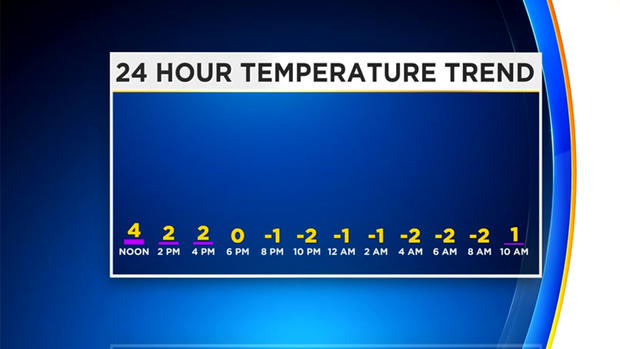
Temperatures will continue to tumble down to zero by dinnertime, and then below zero by early Thursday morning.
"We're talking about temperatures that are about 30 degrees below average," said KDKA meteorologist Kristin Emery.
RELATED LINKS:
The National Weather Service illustrated just how cold it got in Pittsburgh Wednesday morning with the hot water test. They said: "Hot water meets the chilly 4 degrees in Pittsburgh… the hot water rapidly evaporates and then it condenses into a cloud."
Watch it here:
Hot water meets the chilly 4 degrees in Pittsburgh...the hot water rapidly evaporates and then it condenses into a cloud. #CoolScience pic.twitter.com/zkdvmtThiw
— NWS Pittsburgh (@NWSPittsburgh) January 30, 2019
Because of the extreme cold, Wind Chill Advisories and Warnings remain in effect across the region through late Thursday afternoon.
"High temperatures don't normally stay in the single digits around the Pittsburgh area, and then we have wind gusts that could be 20-30 mph throughout today," said Emery. "That's why we have these wind chill advisories and warnings in effect."
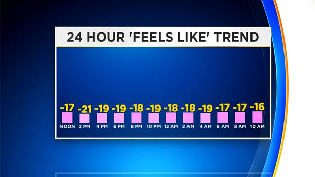
Wind chills will hover at minus-15 to minus-20 degrees through mid-Thursday when the bitter cold finally begins to loosen its grip.
Emery says where the advisory is in effect, wind chills will go down to minus-20. Where the warning is in effect, in the Laurels, ridges and other places to the north, wind chills will approach minus-30.
"As we head through the afternoon, evening hours, through portions of Thursday morning, the wind chills will stay at -15 to -25 across much of southwestern Pennsylvania. The temperature falling to minus-4 for the actual air temperature, which will be close to our record for one day," Emery said,
WEATHER LINKS:
Current Conditions | School Delays & Closings | Local Radar | Weather App | Photos
If you think it's bitterly cold in Pittsburgh, how about parts of the Midwest.
With the wind chill, it was expected to feel like about 50 below zero in Chicago this morning, and Minnesota could see wind chills of 70 below zero.
Because of the extreme cold, there were hundreds of closures around the area. School districts all over the region canceled classes on Wednesday.
To clarify, classes at the Pittsburgh campus are cancelled on Wednesday, January 30 due to weather. Classes at other campuses will proceed as normally scheduled. https://t.co/gfY1RRauom
— Carnegie Mellon (@CarnegieMellon) January 30, 2019
All classes at the Pittsburgh campus are cancelled for today, Jan. 30.
Campus remains open with normal administrative operations. Employees should use discretion reporting to work as outlined in the extreme weather policy: https://t.co/eBIcScRbON pic.twitter.com/LkrVZIv2iW
— University of Pittsburgh (@PittTweet) January 30, 2019
RMU's campus is closed today (Wednesday, Jan. 30) meaning there are no classes.
The PNC Colonial Cafe, RoMo's, and the Yorktown Cafe are all open and following regular operating hours.
The Student Recreation and Fitness Center and the Yorktown Fitness center are both open. pic.twitter.com/2kOmXQr3Sw
— Robert Morris University (@RMU) January 30, 2019
Weather Update: Classes are cancelled for Wednesday, Jan. 30, and Thursday, Jan. 31. Offices remain open. Essential personnel should report.
— Duquesne University (@duqedu) January 30, 2019
But, after this cold snaps lifts later on Thursday, we're in for a wild warm up that will have us flirting with a high of 50 degrees for the start of next week.
"We break out of single digits Thursday and the winds subside a bit, so we'll lose those wind chill warnings in the afternoon," Emery said.
Until then, officials are urging everyone to stay warm and stay safe in this cold by bundling up if you must go outside, or just stay warm inside if you can.
Stay up to date with the KDKA app, which you can download here.