Pittsburgh Weather: Storms Moving In For The Weekend, High Wind Watch Issued
Follow KDKA-TV: Facebook | Twitter
PITTSBURGH (KDKA) -- The pause in active weather is expected to continue today, but after that, conditions will change.
As we head into the afternoon, clouds will remain in place but highs are expected to be close to the 46 degrees we hit yesterday. Winds will be calm and out of the north at 2-5 mph.
Things begin to change as we go into Saturday with a small passing rain chance through the morning along and south of I-70. The chance for rain will be relatively low through 5 p.m.
We expect a push of warm air to arrive around 5 p.m. With the push of warmer air will come a solid chance for rain showers and even some weak storms. KDKA's Ron Smiley says he's not going to rule out some small hail reports also being possible late Saturday night into Sunday morning.
Obviously, more rain is something that we do NOT need, since the ground is already loose from the previous round of precipitation the area has seen.
WEATHER LINKS:
Current Conditions | School Delays & Closings | Local Radar | Weather App | Photos
Finally, high temperatures on Saturday will be reached after 5 p.m. as well. We will likely see the high or at least a near high temperature just before midnight on Saturday.
While active weather is set to return on Saturday, Sunday is the day where we will see the most activity.
At this point, the biggest concern is with wind speeds.
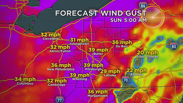
A High Wind Watch has been issued for concerns with strong winds on Sunday. Winds could gust past 50 mph here locally. This is the tenth High Wind Watch that has been issued from this forecast office since 2005, with the last one issued 355 days ago. Smiley believes that puts it at March 3, 2018.
On top of the strong wind speeds, we will also see rain showers with a couple of weak storms being possible.
High temperatures on Sunday will be hit in the morning at around 8 a.m. Temperatures will rapidly fall as a cold front rolls through with temperatures diving from near 60 degrees to mid-30s with snow showers around by shortly after noon.
At this point, it looks like around 0.75 inches of rain will be possible along with just a dusting of snow. Minor accumulation could occur in communities north of I-80 with decent snow totals in the Laurel Highlands.
The High Wind Watch/Warning comes to an end at 7 a.m. on Monday. The rest of Monday is looking dry with the next round of rain and snow expected to arrive late Tuesday.
Stay up to date with the KDKA app, which you can download here.