Pittsburgh Weather: Snow Falling Across Region, Upwards Of 6 Inches Possible In The Laurel Highlands
PITTSBURGH (KDKA) -- People across the region woke up to a light dusting to minor accumulations of snow, but the bigger event will continue into the afternoon hours with snow totals piling up for the higher elevations.
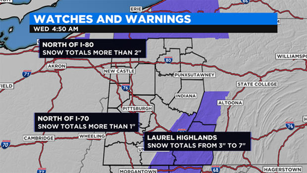
KDKA Meteorologist Ron Smiley says areas north of I-70 can expect snow totals of more than an inch.
Snow (at times mixed with rain for areas to the southwest) will develop this morning and afternoon. Curious when it will start to taper off? Here is a glimpse at when you might expect that snow to end through Thursday morning. pic.twitter.com/Lk3vi3ngZO
— NWS Pittsburgh (@NWSPittsburgh) December 4, 2019
Places north of I-80 should expect to see more than two inches of snow beginning this afternoon and going through Thursday morning.
The Laurel Highlands is a unique case where totals there will vary widely due to obvious issues that occur with hilly elevations. The NWS is forecasting upwards of six inches being possible in isolated spots in the Laurels.
A Winter Weather Advisory is in effect there.
Good morning! Another day...another Winter Weather Advisory for the ridges! We are expecting 3-7" of snow in the highlighted area, with the advisory running from noon today until 7 AM Thursday. Areas near and north of I-80 could see 1-3"during that period, with less elsewhere. pic.twitter.com/cUIYKO59jJ
— NWS Pittsburgh (@NWSPittsburgh) December 4, 2019
The reason for this expected snow is due to a perfect set up with us being at the base of a trough with upper level winds coming out of the northwest. Snow will begin as soon as 8 a.m. to the west, with snow showers picking up through noon.
The heaviest snow for the Pittsburgh area happens from 10 a.m. to 3 p.m. Expect road conditions to quickly change as we have a mid-level low slide through.
WEATHER LINKS:
Current Conditions | School Delays & Closings | Local Radar | Weather App | Photos
The low then lifts to the east this afternoon, leaving us in the perfect set-up for lake effect snow showers and squalls. Expect the new squall warning system to get a workout this afternoon into the overnight hours.
Stay up to date with the KDKA app, which you can download here.