Pittsburgh Weather: Pittsburgh Area Sees Dusting, But Snow Piling Up For Places Further North
PITTSBURGH (KDKA) -- How much snow you saw walking out of your house this morning depends on where you are, but it did make for a tricky morning commute for most.
The precipitation started as snow Wednesday afternoon, but changed over to snow in the middle of the night, with dropping temperatures and wind chills.
The highest snowfall total report thus far has been out of Tucker County, WV where 8.3" has been observed in the last 24 hours. Can anyone else in the ridges beat that?
Otherwise, most locations are reporting trace amounts. pic.twitter.com/9BjjqKlwog
— NWS Pittsburgh (@NWSPittsburgh) February 27, 2020
KDKA Meteorologist Ron Smiley says we can expect a high of 35 degrees this morning. However, with wind chills this morning, the temperatures felt more like 10 degrees.
WEATHER LINKS:
Current Conditions | School Delays & Closings | Local Radar | Weather App | Photos
While the Pittsburgh area saw about a dusting, the higher elevations got more.
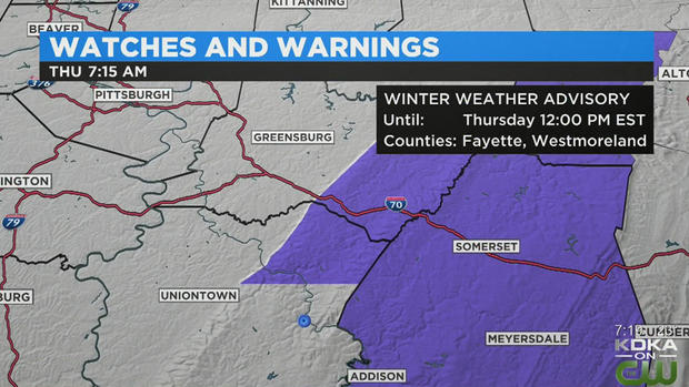
A Winter Weather Advisory remains in effect for the Fayette and Westmoreland Ridges until noon.
"It's going to be the usual spots – the Laurel Highlands, the Ridges. They have some decent snow this morning. Also, in the snowbelt is seeing some decent snow totals," Smiley said. "But, overall, we're generally looking at what can be categorized as a little bit more than a dusting of snow that's on the ground. It's really not much for most folks. That's even in spite of the fact that radar has looked fairly impressive all morning long, it just hasn't translated to what we're seeing on the ground."
However, it's a much different story further to the north where Crawford and Erie counties are under a Lake Effect Snow Warning until 6 p.m. Saturday. There are blizzard warnings for area to the north as well.
4:40 AM radar. We are using a different color scheme here to give a bit better detail to where the steadier snow is. Despite the appearance of oranges and reds, the snow is not excessively heavy in most cases.
We've got 0.3" on our snowboard right now. How much have YOU got? pic.twitter.com/t3g31Cm271
— NWS Pittsburgh (@NWSPittsburgh) February 27, 2020
If you don't like this weather, just hang on a few days and it'll be out of here.
The weekend will be mostly chilly, but the 50s will be back by the beginning of next week.
Stay up to date with the KDKA app, which you can download here.