Pittsburgh Weather: Cool Temperatures, Rain Chances
PITTSBURGH (KDKA) -- It's shaping up to be another wet week throughout Western Pennsylvania.
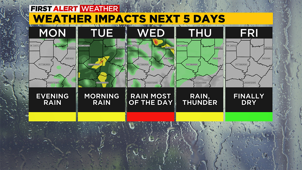
Today: Isolated (most dry) afternoon rain with widespread showers moving through overnight. Along I-80, rain could start as soon as 3 p.m Allegheny/Westmoreland will have to wait until nearly sundown
Alert: No First Alert Weather Days are likely over the next week even with several rain chances.
Aware: Later this week we will see sunset times pass 8:00 p.m. Yesterday was the 100th
day of the year. 56 days have recorded at least measurable rain. 49 days have been
cloudy.
We have several 'quick hit' systems that will be sliding through over the next couple of days.
Right now I have four systems impacting our area through Thursday morning so basically one a day.
The first chance for rain arrives this afternoon and will only be an isolated chance for rain, meaning most will be dry.
Even if you see the isolated rain showers, rain will not last long this afternoon. As the sun is setting, round two of rain is set to arrive with showers around through the overnight hours.
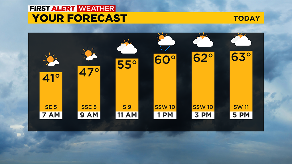
Rain should be wrapping up in the middle of the Tuesday morning rush.
Kids will probably want to grab their jackets as they are heading to the bus stop.
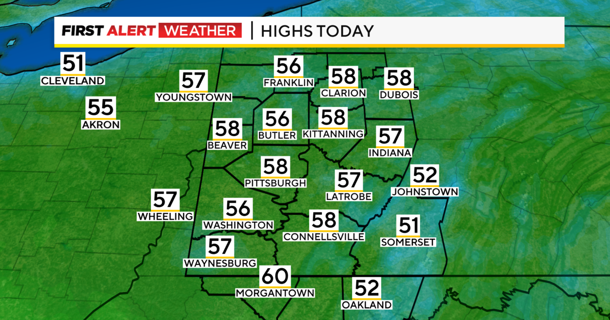
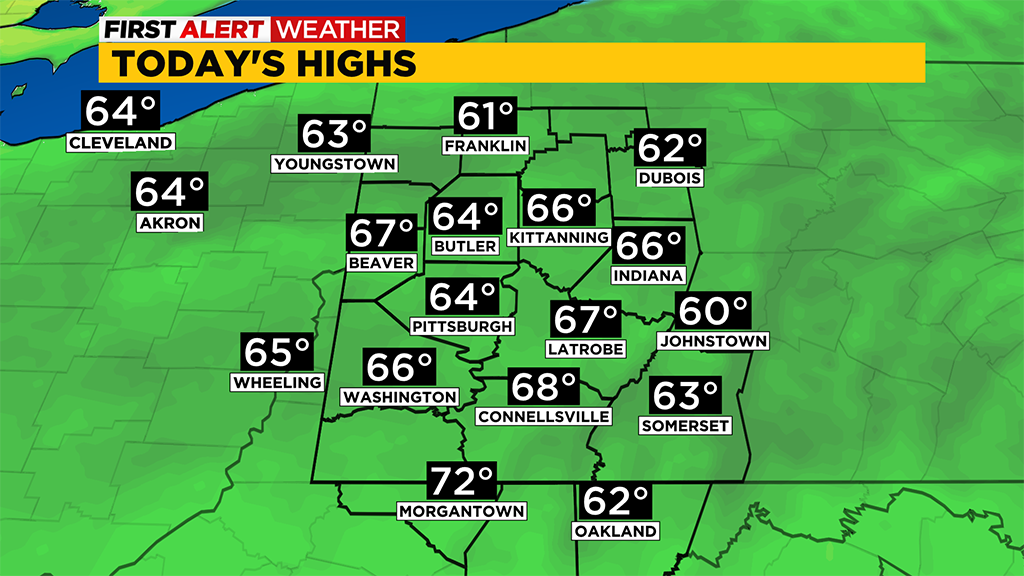
Temperatures today should be comfortable with morning lows near 40 degrees and already ticking up.
Highs today will be in the mid 60s with a brief little bit of sunshine arriving before 10 a.m. and overcast skies in place for the rest of the day.
There will be some variability with winds with a general southerly direction. Wind speeds will really pick up tonight as the bigger system rolls
through.
Let's talk about Tuesday, as I was probably the only one to keep Tuesday's highs in the 60's most of last week.
It was always problematic to me to have Tuesday's temperatures that much more than Monday due to a much cooler air mass in place. Yes, there will be lots of sunshine for the afternoon and that may lift highs up a tick or two above today but winds out of the north for the day along with the cooler air mass should lead to cooler temperatures also being in place.
I have Tuesday's high hitting just 62 right now. That is the same temperature I had since Wednesday of last week when everyone else had us in the 70's for Tuesday.
Warmer air is set to arrive on Wednesday morning with a brief rain chance as the front slides through.
This should be the driving force behind us hitting the 70s on Wednesday. I'm forecasting a Wednesday high of 75 degrees.
There is a solid chance for rain on Wednesday but most of the rain falls in the afternoon and evening with just that brief morning rain chance.
Looking ahead to Easter Sunday and the weekend, Saturday is looking wet for the day with rain through the day and highs in the 50's.
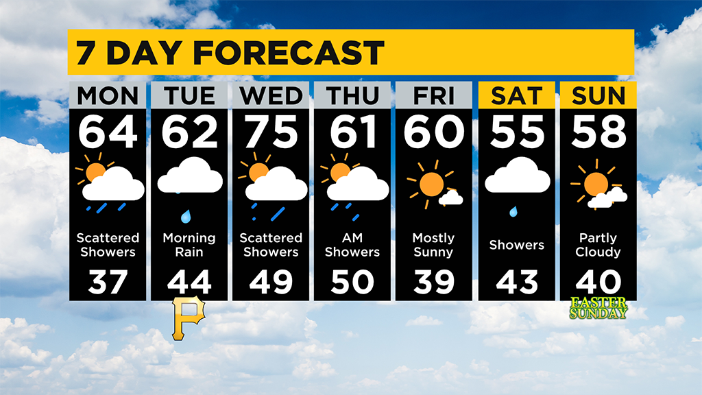
Easter Sunday is looking dry but damp with a high of 58 degrees. I have a 20 percent rain chance on Easter due to our area being between two
potential weather makers.
WEATHER LINKS:
Current Conditions | School Delays & Closings | Local Radar | Weather App | Photos
Stay up to date with the KDKA app, which you can download here.