Pittsburgh Weather: Weekend Storm Could Bring Snow, Ice, Rain
Follow KDKA-TV: Facebook | Twitter
PITTSBURGH (KDKA) – While all eyes are on the upcoming weekend, where forecasters say the Pittsburgh area could get a lot of snow, rain and ice, there are other weather disturbances prior to then to pay attention to.
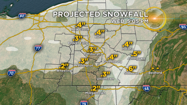
The first snow-making disturbances will pass through the area early on Wednesday.
While accumulations will be minimal, there could be some patchy freezing drizzle mixed in.
This could lead to slick spots, especially early Wednesday.
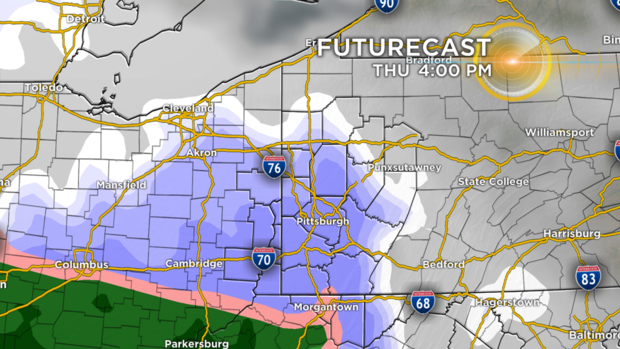
The second snow maker arrives Thursday afternoon into early Friday. This one will actually feature both rain and snow, so it will hold accumulations down. Generally, an inch or less is expected south of Pittsburgh, up to 2 inches in the city and 1-3 inches closer to I-80.
The accumulations are obviously not big, but this will be a slushy variety of snow, so it could be slick.
The storm getting all the attention comes Saturday afternoon. The intensity and impacts of that system are still undetermined as a reliable track has not yet been established. It is too soon to give snow totals for this weekend as 50 miles could mean the difference between rain and very heavy snow.
Here's more details from KDKA Meteorologists Ron Smiley, Ray Petelin and Jon Burnett:
System #1: The first arrives early on Wednesday morning. This comes in the way of a small clipper that will drop a small trough through area.
Snow totals for this system are way down at this time, perhaps a dusting to a half inch of snow over the course of about 6 hours. The best news is that snow is not expected to start until after the Wednesday morning commute and end just before the evening commute. This should have a minimal impact on area drivers.
System #2: Expected to arrive around 5 p.m. on Thursday. That means part of the evening rush will likely be impacted, especially for those traveling along I-79 and I-70 southwest of Pittsburgh. Snow totals with this system are around an inch when looking at model data coming in.
Most will see an inch to an inch-and-a-half. Snow totals will be impacted by rain showers arriving just before midnight.
Friday will see isolated rain and snow showers early with windy conditions for Friday morning. This system will have a low impact on roads.
System #3: This one is the one everyone is buzzing about. A big Nor'easter developing and dropping a lot of snow.
This system will arrive Saturday and at this point most will start off by seeing rain.
Rain will eventually change over to snow and there is still a chance for some relatively large snow totals. At this time, some freezing rain and sleet cannot be completely ruled out. This system will have a moderate to high impact on area roads.
"The storm has shown some big snow totals on models," Smiley said. "At this time it looks like a mixture of both snow and rain."
Stay up to date with the KDKA app, which you can download here.