Pittsburgh Weather: Arctic Air Sliding Back Into Area Bringing Chance For More Snow
Follow KDKA-TV: Facebook | Twitter
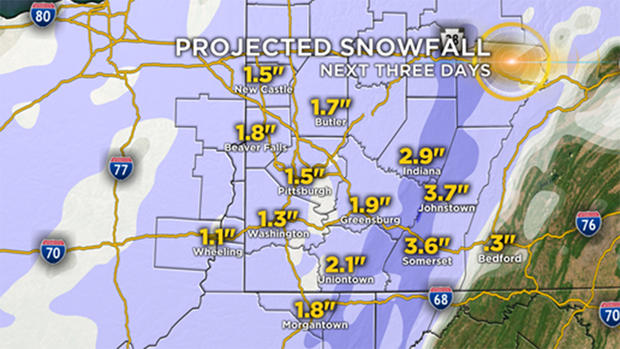
PITTSBURGH (KDKA) -- With the chill comes the chance for more snow.
At this point, it looks like the area will see at least two chances for snow over the weekend with what we call "clipper lows."
"Clipper lows" are fast-moving, mid-level lows that move along the polar jet. Sometimes these lows are so small that model data can miss one or two. This poses a problem because these fast-moving systems can easily drop two to four inches of snow.
Will one of the systems pushing through bring an unexpected amount of snow?
Probably not, but it is something worth watching.
The first mid-level low slides through on Saturday and should only bring a small chance for snow. The low will pass north of I-80 right along the banks of Lake Erie. This area of low pressure will bring a snow chance from 6 p.m. through Sunday morning.
WEATHER LINKS:
Current Conditions | School Delays & Closings | Local Radar | Weather App | Photos
The second system comes in late Sunday into Monday, bringing a better chance for snow. Timing of this system is probably after 8 p.m. on Sunday through 5 a.m. on Monday. Right at an inch is expected.
While it doesn't look like snow totals will get too crazy this weekend, the outlook can quickly change.
Stay up to date with the KDKA app, which you can download here.