Pittsburgh Weather: Tornado Watch Issued, Storms Could Bring Lightning, Hail And Destructive Winds
PITTSBURGH (KDKA) -- Stormy conditions are expected today.
At this point, the window for the severe weather is relatively broad starting at 2 p.m. and going through midnight.
As if on cue, just before 2 p.m., the National Weather Service issued a Tornado Watch for parts of Pennsylvania, Ohio and West Virginia through 10 p.m.
A tornado watch has been issued for parts of New Jersey, Ohio, Pennsylvania and West Virginia until 10 PM EDT pic.twitter.com/lx1dR0n38e
— NWS Pittsburgh (@NWSPittsburgh) May 28, 2019
The watch is in effect for Allegheny, Armstrong, Beaver, Butler, Clarion, Fayette, Indiana, Jefferson, Lawrence, Mercer, Venango, Washington and Westmoreland counties.
The set-up for today has us between high pressure to the south, situated over Georgia and the Carolinas, with an upper low located over northern Ontario. The subtropical jet is parked right overhead.
Several dynamics are coming into play to make for a nasty set-up, including speed sheer aloft along with divergence of air aloft and convergence of air at the surface. This will likely cause a relatively narrow band of storms spanning from the west to the east. As storms fire along this line, they will move quickly from west to east. Lightning, large hail, destructive straight line winds and tornadoes will all be possible through the day today, but mainly starting after 2 p.m.
Break this morning. Storms this aft/eve. Unstable air, strong wind field, and efficient storm movement. This will sharply increase the risk for severe storms. Damaging wind gusts, large hail and yes even a tornado. Stay updated on the forecast and any watches/warning. pic.twitter.com/oP8euifgfG
— NWS Pittsburgh (@NWSPittsburgh) May 28, 2019
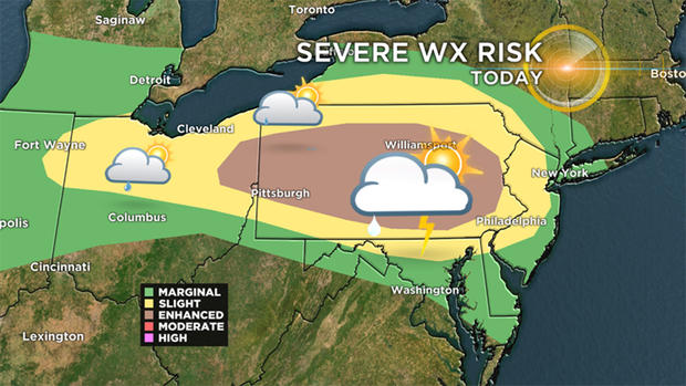
Right now, the area is painted under an enhanced risk of severe weather. This is the third of five tiers, and generally indicates a low risk of tornadoes along with other severe weather being possible. We may hit high enough percentages to see a (rare for this area) moderate risk being issued for parts or Pennsylvania.
This is the first of three straight days where severe weather will be possible across the state and here in Western Pennsylvania. Buckle up.

WEATHER LINKS:
Current Conditions | School Delays & Closings | Local Radar | Weather App | Photos
Highs today should hit the mid-80s before rain showers and storms arrive. Winds will gusty, coming out of the east at 7-17 with wind gusts around 30 mph. Highs will probably be reached around 3 p.m., just ahead of storms dropping in from the north.
Wednesday highs will fall to near 80 degrees. The 70s will be back for highs on Thursday, lasting into the weekend.
Over the next seven days, only one (Monday) is forecast to be dry.
Stay up to date with the KDKA app, which you can download here.