KDKA 2020-2021 Winter Weather Forecast, Slightly Warmer This Season
By: KDKA-TV News Staff
PITTSBURGH (KDKA) -- When you put together a long-term forecast, the first thing you do is look for the most likely storm track -- the bigger pattern that will be the driver of the whole season.
From there, you try to figure out the finer details.
Last year, we predicted winter to start late. That happened.
We predicted frequent bouts of rain and snow. That also happened, but it came mostly as rain.
We were looking for a cold snap in January and February. That didn't happen, and that's what put the kibosh on our overall snowfall for the year.
So we got some things right and some things wrong.
WEATHER LINKS:
Current Conditions | School Delays & Closings | Local Radar | Weather App | Photos
This year, though, we have a major player in the atmosphere to help us determine our storm track.
What's happening down in the Pacific Ocean near the equator often plays a big role in our winter weather pattern.
In an El Nino pattern, trade winds weaken, leading to unusually warm water in the tropical Pacific. This forces a southward shift of the jet stream.
During a La Nina pattern, there are unusually cold conditions in the tropical Pacific. This displaces the jet stream northward. That can lead to a wetter, colder winter for the northern U.S. and a drier, warmer winter for the south.
We were in a neutral pattern much of last year.
But sea surface temperatures in the tropical Pacific have now dropped, prompting a La Nina advisory. And there's a 75% chance those conditions will stick around this winter.
A La Nina year could bring a mix of things, and it only takes one bad snowstorm to push records.
In the past decade, we've had four La Nina years.
During the winter of 2010-2011, there was a strong La Nina presence and an above-average snowfall of 56.7 inches.
The following winter, 2011-2012, La Nina was moderate with 36.9 inches of snowfall, which is just slightly below normal.
Fast forward to the winter of 2016-2017, La Nina was weak with a below-average snowfall of 32 inches.
But it was also weak the following winter, and we ended up with nearly 60 inches of snow, which is way above average.
We're expecting a moderate La Nina this winter, which probably means a little warmer than average.
However, in addition to La Nina, we have another player that will arguably impact our winter weather even more.
It's the North Atlantic Oscillation, or N.A.O. for short. It's basically a measurement of a persistent area of high pressure off the East Coast. It's what explorers used to help them navigate across the Atlantic Ocean centuries ago.
A positive N.A.O. number means warmer air, and that's what we're currently seeing -- a strengthening N.A.O. that's already positive.
So with all that in mind, we're going to forecast a slightly warmer than average winter this year.
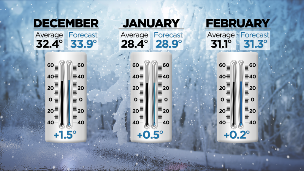
Winter will start off warm with December temperatures averaging 33.9 degrees, about a degree and a half warmer than the average.
January average temperatures could be somewhere around 28.9 degrees, about half a degree warmer than average.
And February is looking pretty normal, at 31.3 degrees on average, just a few tenths of a degree warmer than average.
Now, what about snowfall?
The past couple winters have been exceptionally wet. Not necessarily white, but certainly wet.
That changed this summer, with drought conditions unfolding. And that overall dry trend looks like it's going to continue, at least for the next couple of months.
The warmer than average temperatures also are going to be a factor in how much snow we'll see this winter.
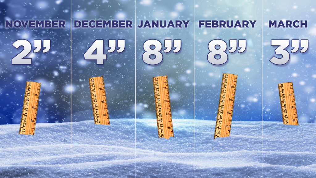
The rest of 2020 is likely going to come in with below average snowfall, especially since it'll still be so dry.
We're calling for two inches for the rest of November and four inches in December.
January and February will still likely be our snowiest months, as usual. But that's not saying much, since we're expecting below average snowfall then, too.
Eight inches is what we're expecting in January, and as moisture trends start to increase a bit, we're looking for another eight inches in February.
March has brought some big snows to Pittsburgh in the past. This year, not so much. We'll see some rain, but in terms of snowfall, we're expecting just three inches.
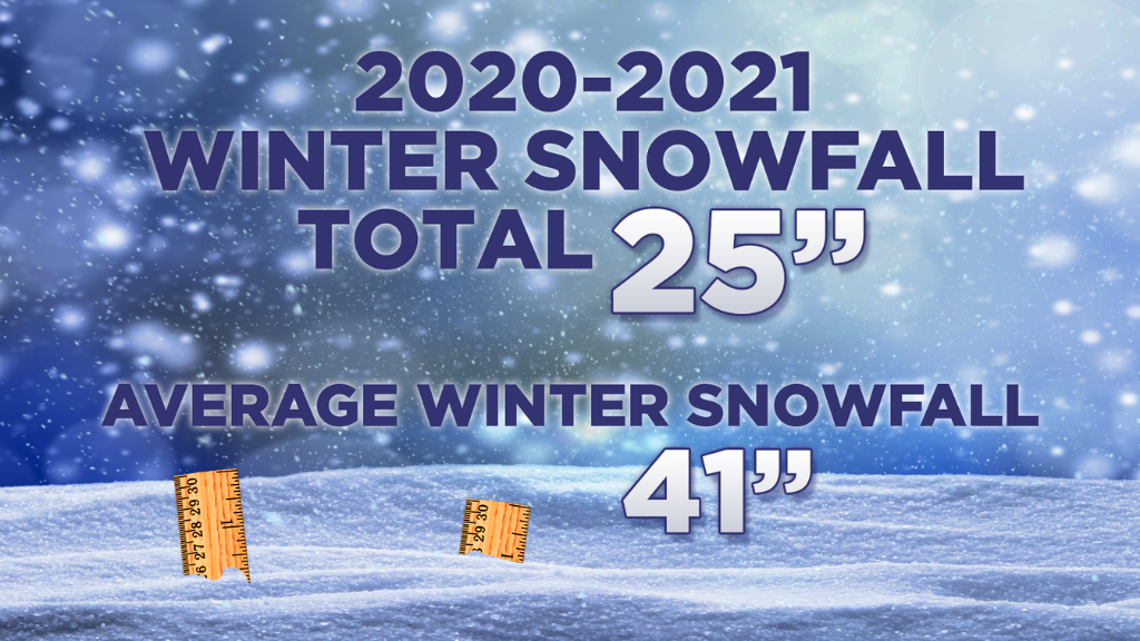
That brings us to a grand total of 25 inches of snow for this winter, well below the 41-inch snowfall average for the Pittsburgh area.
Stay up to date with the KDKA app, which you can download here.