Pittsburgh Weather: Additional Accumulation Expected As Snow Will Change From Steady To Scattered Throughout Day
PITTSBURGH (KDKA) -- Let it snow.
A snowy Tuesday is on tap for all of Southwestern Pennsylvania as we're looking at steady snowfall to scattered snow showers continuing up until around 8 p.m. to 9 p.m.
After that, everything will slowly wind down and only a few Lake Effect snow showers will remain overnight into Wednesday morning.
WEATHER LINKS:
Current Conditions | School Delays & Closings | Local Radar | Weather App | Photos
Look for a few more inches of snow piling up across the region with higher totals in the Laurel Mountains and up along and north of I-80.
The National Weather Service said it has snowed 6.8 inches in Pittsburgh, which is the snowiest day of the year so far.
These are the additional accumulation totals we can expect today:
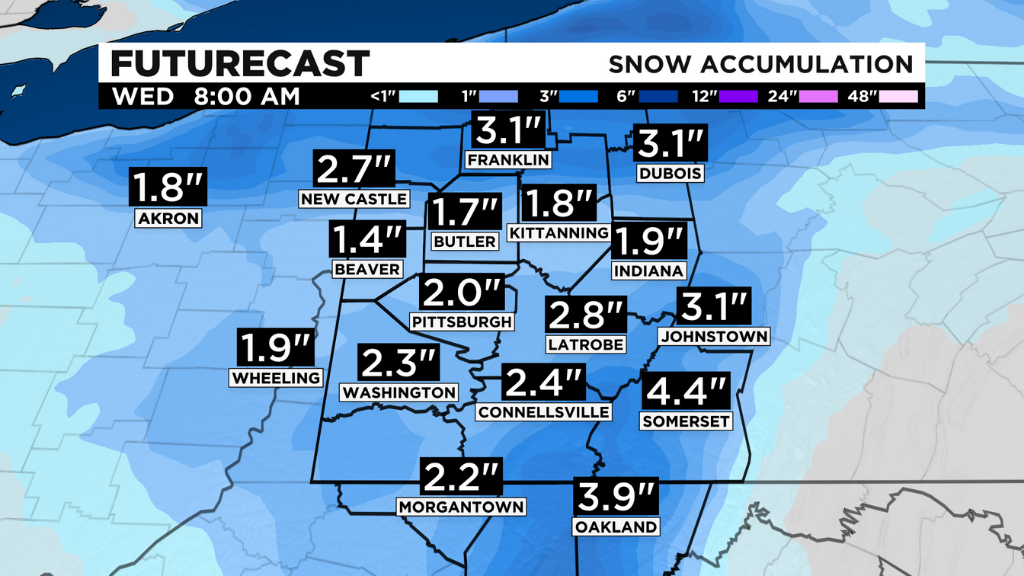
The Winter Weather Advisory and Winter Storm Warning remain in effect through 7 a.m. Wednesday.
Sun will gradually emerge tomorrow afternoon with highs in the upper 30s, and we rebound into the 40s for the rest of the week, starting Thursday.
Stay up to date with the KDKA app, which you can download here.