Limited Visibility, Accumulating Snow And Icy Spots: Road Crews Get Ready As Snow Heads Our Way
By: KDKA-TV News Staff/Kristin Emery
PITTSBURGH (KDKA) -- The Allegheny County Public Works Department is preparing for an overnight snowfall that could leave a few inches behind by the Tuesday morning rush hour.
The snow is expected to start moving in around 9 p.m. and leave 2-4 inches by morning. In addition, temperatures will be very cold, which will cause dangerous icy spots for drivers.
The National Weather Service has issued a Winter Weather Advisory for much of the western side of Pennsylvania, as well as parts of Ohio and West Virginia. It begins at 9 a.m. and continues through 1 p.m. Tuesday.
Winter weather advisory issued for tonight... @KDKA pic.twitter.com/ObnSyymlEr
— Kristin Emery (@KristinEmery) February 8, 2021
Public Works Director Stephen Shanley says the department will have 24 salt/plow trucks out once the snow starts to fall.
Shanley says, "If the forecast changes, we may adjust our plans. That might include bringing in more drivers and extending shifts to ensure continual coverage of our roadways until the snowfall ends on Tuesday.
"Snow overnight and into the beginning of the morning rush hour could be heavy at times, and drivers might experience limited visibility. Also, air and pavement temperatures are predicted to be in the middle to upper 20s, so there likely will be slick spots on roadways, especially on bridges and ramps. We urge drivers to slow down, plan additional time for their commute, leave extra space between their vehicle and the ones in front of them, and please give our salt truck drivers plenty of room to navigate."
WEATHER LINKS:
Current Conditions | School Delays & Closings | Local Radar | Weather App | Photos
In the city, Pittsburgh Public Works is preparing to salt and plow the roads. They'll deploy 45 trucks Monday night, and over 60 trucks will be available for Tuesday.
The City Snowplow Tracker App will be activated Monday at 11 p.m. and throughout the storm.
KDKA Meteorologist Kristin Emery says those along the I-80 corridor can expect some snow showers this afternoon ahead of the accumulating snow.
Expect a general 2-4 inches of snow across the region by Tuesday mid-morning and that will impact the morning commute.
Snow tapers off by lunch Tuesday and we have another round on the way Wednesday night, which could drop another couple of inches through Thursday.
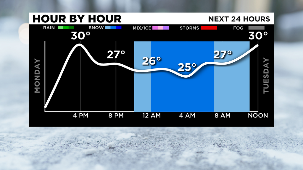
Temperatures bottomed out in the upper single-digits and lower teens across the area this morning and we will only bounce back to around 30 for an afternoon high, leaving us in the ballpark of 5-10 degrees colder than our normal highs this time of year in Southwestern Pennsylvania.
However, temperatures will remain colder than average all week with some very chilly air on the way for the weekend and Valentine's Day.
Stay up to date with the KDKA app, which you can download here.