Pittsburgh Weather: Everything You Need To Know About Sunday's Winter Storm System
PITTSBURGH (KDKA) - What could potentially be the biggest snow event of the year is heading our way.
While the system is two days out and there's plenty of time for information to change, current data shows it's pretty likely Pittsburgh will see at least 5 inches of snow.
A lot goes into forecasting a big weather event. KDKA Meteorologist Ron Smiley is breaking it down and answering all your questions.
Ron Smiley's forecast
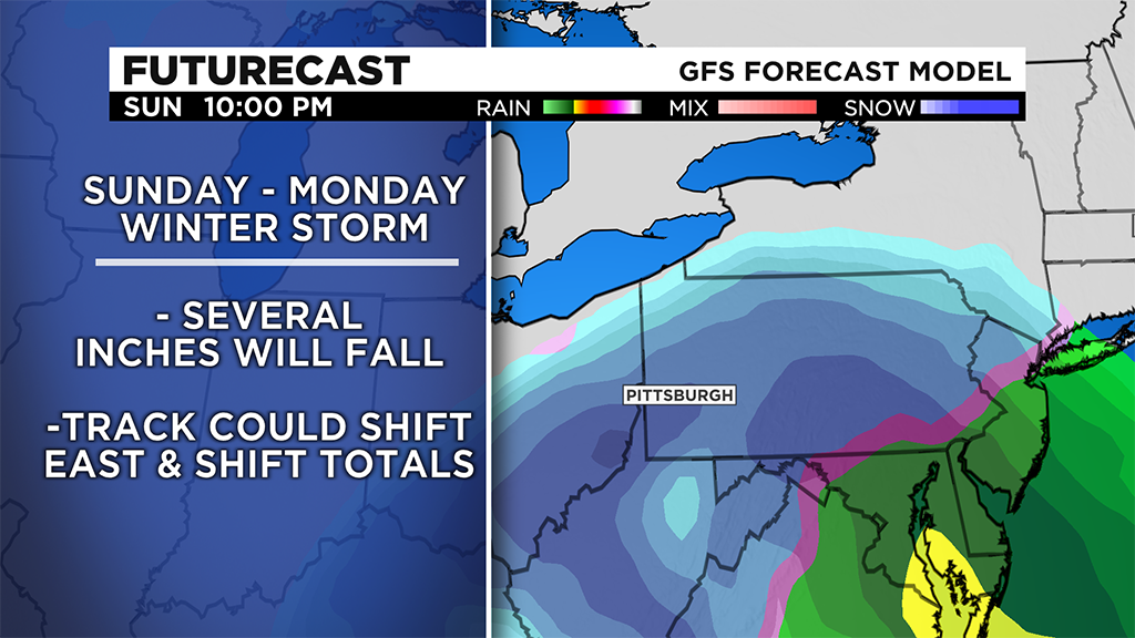
Let's talk about snow. This is meant to be a place right here where you can come to get everything you want to know about the impending big snow chance coming in on Sunday afternoon through Monday morning. Let's start you off with the official snow map with projected snow from the KDKA weather team.
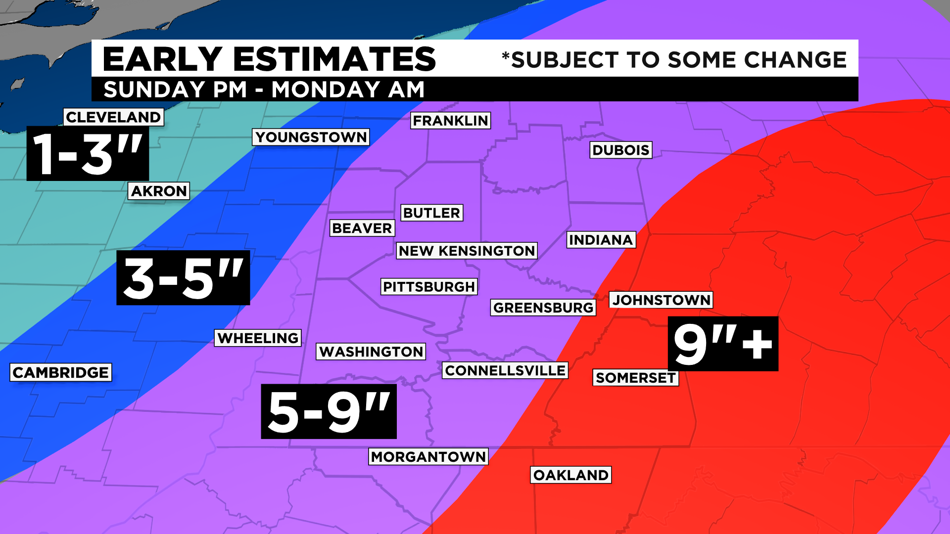
There will be changes. There always are, and we're still two days out from the start of the event. But this is what the latest data is telling us to expect.
This system hasn't fully formed yet, so the best tool we have to forecast this event is data that has gotten a lot more right over the past decades than it has gotten wrong. So from there, let's get into more details.
What is going on?
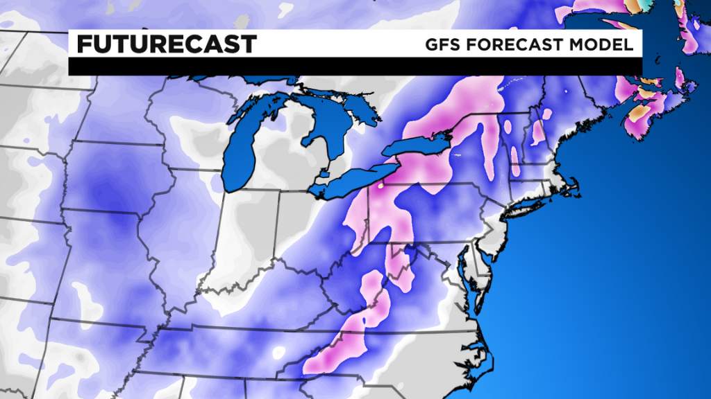
A mid-level low is forecasted to track just southeast of our area on Sunday afternoon through Monday morning. The low will swoop into the U.S. from Canada, moving south southeast into Minnesota.
The track will take the system south to Arkansas where it is projected to make a hard left turn to the east. This track will take it over Kentucky and Tennessee before it begins to move back northeast along and slightly east of the Appalachian mountains. We will be in what is called quadrant four of a jet streak. During the winter, this is the area that often gets big snow totals in this type of setup. We expect to see big snow totals.
When will we see any watches, warnings or advisories?
Normally for winter weather, watches and advisories are issued 24 to 48 hours out. Warnings and advisories usually replace watches, if warranted, with 24 hours or less to go.
We already have winter storm watches posted for Sunday into Monday. They were issued early Friday morning. Yes, this was early and that is a combination of a couple of things.
First off, confidence in this event is high. The National Weather Service -- which issues watches, warnings and advisories -- leans heavily on a computer program called the National Blend of Models (NBM). This program mixes 46 models together, reduces the inherent biases that come from all models, and then outputs what it thinks is the best solution.
Out of the 46 models that the NBM uses, only three are showing Pittsburgh not seeing more than 5 inches of snow.
Second, the timing of this system is late in the weekend. People are much more likely to notice a warning on Friday than they are on Saturday.
Finally, this is a large system that will impact a number of people's lives. The best warnings come early and often. Looking at the history of our region, this type of storm should be expected about once every two years if we see 6 inches of snow and about once a year if it's 5. This may very well be the biggest snow event of the year.

When can I expect snow?
There is a Winter Storm Watch in effect from 1 p.m. Sunday through 1 p.m. on Monday. I have the heaviest of the snow in place after sunset and continuing through sunrise on Monday morning. I actually have Western Pennsylvania mainly snow-free through at least 4 p.m. on Sunday with snow arriving in Pittsburgh around 6 p.m.
The heaviest of the snow will move through from 8 p.m. through around 5 a.m. on Monday morning. This means anyone traveling home after the Steelers playoff game will see snow-covered roads. If you are planning on Ubering home, be prepared for high prices.
Monday is a federal holiday, but for those traveling into work, roads may still be snow-covered in places. I would expect this will certainly be the case on many neighborhood roads and some secondary roads.
So it's done, there is no way we see less than 5 inches?
I wish I could guarantee 5 inches of snow. I can't. All I can do at this time is tell you that there is a high probability for a large snow event on Sunday into Monday. All our best tools are pointing to that and I would not be doing my job if I didn't convey that to you.
At this point, the track is pretty much set in stone. It's not going to change very much. Intensity may change a bit and that could certainly change our forecast when it comes to projected snow.
The most likely change will come as we begin getting short range high resolution model data. This will better show if and how far north any warm air may move into this system. This would cause rain instead of snow.
Does anyone remember the busted forecast of January 2019? I do. In fact, if you Google that busted event you will see one of the first articles is my blog post about the chance for a bust in the forecast going up. I posted that a full day before the busted forecast occurred. I also remember it for some other crazy reasons but you don't need to know those details.
A warm mid-level layer brought rain instead of snow that day for Western Pennsylvania turning a forecast of 4 to 6 inches into slush and rain for the day in Allegheny county. At this point, all signs point to this being an all snow or mostly snow event depending on where you are.
WEATHER LINKS:
Current Conditions | School Delays & Closings | Local Radar | Weather App | Photos