Powerful Storms Move Through, Cause Flash Flooding In Fayette Co.
PITTSBURGH (KDKA) – Storms battered the region Wednesday morning, and when it finally moved out, people were left cleaning up a big mess thanks to flash flooding.
People in Fayette County were hit especially hard, but there were reports all across the area.
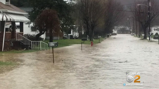
In Glendale, West Virginia streets are covered with water. In some places, it looked like a river was running down the road.
In Ross Township, Gass and Golf roads are flooded. And in South Fayette, Boyce Road at Mayview Road is closed because of flooding.
One of the places hardest hit by the flooding was Washington Township, Fayette County. Victoria Petrosky found water pouring into her home Wednesday morning.
"Wasn't really expecting three-feet of water in the basement," she said. "We've got to check and see if the hot water tank is going to work and if the furnace is."
The Washington Township Fire Company spent the day helping residents pump water out of their homes.
"We're going to be busy all day," said the department's Ernest Colelli. "You get this rain, its coming. There's probably about three or four other houses that are… as soon as they open the basement door, they're going to be calling."
In Perry Township, the B&B Diner was open if you could wade through several feet of water.
"Probably within an hour after I was here, the parking lot over at the carwash started to fill up pretty good," said Kim Brown, of the B&B Diner. "The pump over there is helping, 'cause if not, it would be really high right now."
The rising waters of Mounds Creek in Connellsville were threatening to flood some nearby homes.
Beverly Soisson, who lives nearby, was hit with flooding a few months ago, too. Her basement flooded again Wednesday, and she was packing just in case the water got any higher.
"I looked back and seen it was rising, and I thought, 'Oh, no, not again,'" said Soisson. "I already said, if it happens again, we're moving and we're moving out of state."
Flooding was also reported in Waynesburg, Greene County. Photos on social media show pools of water on area sports fields.
Well... it happened again ! pic.twitter.com/PoNuS55IBY
— Waynesburg Football (@WU_SWARM) March 2, 2017
High water from today's severe storms pose another flooding threat to Waynesburg University's John F. Wiley Stadium. pic.twitter.com/eR3NuRX6De
— Yellow Jacket (@WUYellowJacket) March 1, 2017
The evening hours brought some additional rain to the area, but with none of the severity as the storms in the early morning hours. Still, there were still some active alerts.
A Wind Advisory was issued for Allegheny, Armstrong, Beaver, Butler, Clarion, Fayette, Forest, Greene, Indiana, Lawrence, Mercer, Washington, Westmoreland and Venango counties from 7 p.m. tonight through 7 a.m. Thursday.
WATCH THE LATEST FORECAST:
The National Weather Service also issued a Flood Warning for Greene, Fayette, Washington, Westmoreland counties.
"That's for some creeks and streams that have gotten out of their banks in the wake of those very heavy rains this morning," said KDKA-TV Meteorologist Dennis Bowman.
Earlier in the day, a Tornado Warning was issued for Greene and Washington counties, but that warning has since expired.
Meanwhile, a Flash Flood Watch is in effect for the following counties through 8 p.m.: Allegheny, Fayette, Greene, Washington and Westmoreland.
WEATHER LINKS:
Current Conditions | Local Radar | Weather App | Photos
According to Bowman, the atmosphere stabilized in the afternoon hours, which inhibited any additional severe weather. However, some showers were still moving through the area, but without the thunder and lightning.
As for the Wind Advisory, Bowman says some gusts could get to 45 miles per hour, creating a nuisance with objects being blown around and making it tough for high-profile vehicles to operate.
WIND DAMAGE:
The wind may have caused some damage at the New Grenada Theatre in the Hill District. There was a partial collapse there Wednesday evening and the bricks and debris that came down hit an electrical meter and pole.

Today's high temperature is expected to be 66 degrees, but colder weather returns for the rest of the week.
Bowman says there will be a snow flurry or two overnight as we turn colder.
"This is with our actual cold front that's going to turn the temperature around a little bit later on, but in the meantime, look for a bumpy ride with some gusty winds and also some briefly heavy rain as this narrow band of rain activity comes in," he said.
For Thursday, we can expect a couple of morning snow showers with little to no accumulation. But otherwise it will be mostly cloudy and brisk with a high of 41. In the evening hours, it will be mostly cloudy with some light snow, accumulating to a coating to an inch by morning.
A few snow showers will continue on Friday with blustery and cold conditions. But little, if any, additional accumulation.
Into the weekend, the cold will persist on Saturday with an bit of an expected warm up on Sunday.
Join The Conversation On The KDKA Facebook Page
Stay Up To Date, Follow KDKA On Twitter