Pittsburgh-Area Flooding Expected To Be Minimal Despite Previous Predictions
Follow KDKA-TV: Facebook | Twitter
PITTSBURGH (KDKA) – Pittsburgh was preparing for the worst last week, but while rivers were still rising on Sunday, flooding was expected to be minimal.
The 10th Street Bypass was closed as a precaution, but there was no flooding, and thanks to industrial-sized pumps, the Parkway East "bathtub" section remained mostly dry and open Sunday.
While the river spilled onto Point State Park and the North Shore, folks were out enjoying the park anyway.
By mid-day, the National Weather Service said the threat of flooding was "pretty much nil."
So what went wrong with the forecast that was warning of record flooding? The explanation isn't very complicated.
"We've gotten significantly less rain than was originally anticipated," hydrologist Lee Hendricks with the National Weather Service said.
Ross Guidotti's Report:
The area was bracing for a record flood over the weekend with several inches of rain expected on the already saturated ground. It never came.
"The rainfall that was expected was broad enough in scope and significant enough... There was a possibility of flooding to rival Hurricane Ivan," Hendricks said.
How could the forecast be so wrong? Blame it on the computer models.
"Models are not perfect," Hendricks said.
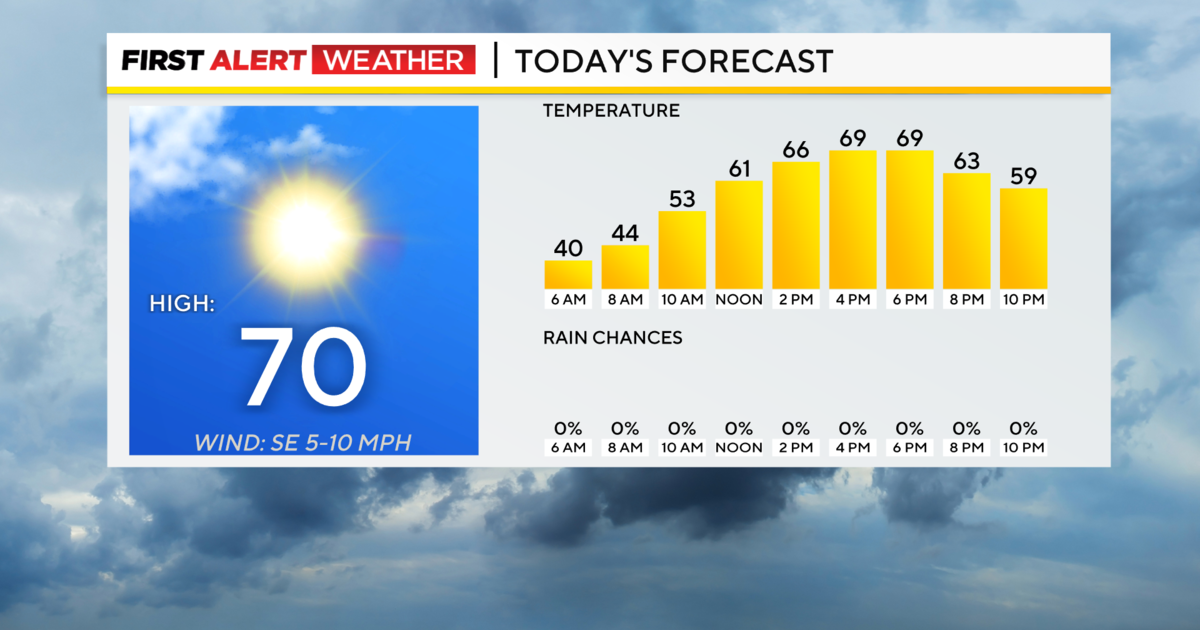
By late in the day, the sun was actually peeking through the clouds.
Still, it's not over just yet.
The Mon Wharf is flooded and will be closed Monday. The rivers won't crest until Monday morning, and the 10th Street Bypass and the North Shore could still get some flooding before it's all over.
But it could have been a lot worse.